A Threat to Egypt’s Water and Agricultural Security

May 2, 2017

http://e360.yale.edu/features/vanishing-nile-a-great-river-faces-a-multitude-of-threats-egypt-dam

This article from Yale’s School of Forestry and Environmental Studies discusses a new proposed dam in Ethiopia, along the border between Sudan and Ethiopia.  It would be placed along the Blue Nile River, having significant effects on the region.  Not only will the Grand Ethiopian Renaissance Dam cut off one of the Nile River’s main sources of water, it will also decrease the influx of sediment to the Nile River Delta, already struggling because of the Aswan Dam on the border between Egypt and Sudan.  Concerns have risen from the rising tensions between the three countries, with hopes that the U.S. and China could be arbiters in negotiations about the dam’s development.  The author also notes that the company developing the dam performed the initial feasibility results, leading to clear conflicts of interest by placing an excessive rating on the dam.  This will only fuel the demand by Ethiopia to complete this dam, further increasing tensions within the region.  This is a situation to monitor closely as the placement of the dam could both help provide electricity to the citizens of Ethiopia yet significantly reduce agricultural yields in Egypt.

Paleoclimate in Tibet & CT?

April 30, 2017

Researchers from the University of Rochester have been using stratigraphy within the Qaidam Basin of Tibet to unravel how climate has changed during the Miocene. Color, according to one of the researchers, can be a good indicator of past climate. Red indicates a wetter climate while white indicates a dryer climate. I wonder if the stratigraphy we mapped in Manchester, predominantly red in color, would indicate a wetter climate as well? Follow the link below for more details on the Tibet paleoclimate research.

Link: https://www.sciencedaily.com/releases/2017/04/170406121538.htm

Protection against long shore drift

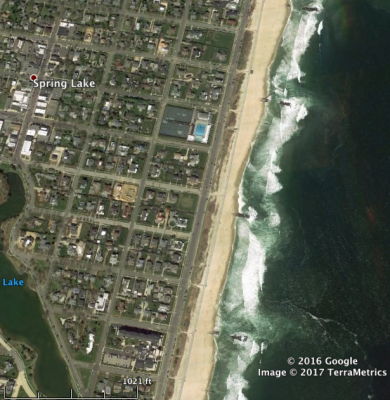
This picture is a screenshot of the coast in Spring Lake New Jersey. Along the shore you can see multiple jetties along the beach. These jetties are used to limit the effects of long shore transport of beach sediment. Jetties are extremely common throughout New Jersey beaches to limit coastal erosion and are very effective.

Turbidity currents

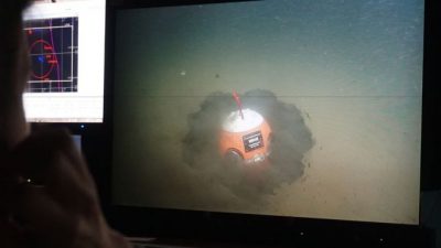
This article discuses a recent turbidity current that scientists were able to record. The scientists used boulder shaped sensors to monitor the turbidity current by rolling with the flow. The smart sensors clocked the flow at 18 miles per hour. The article also talks about a previous turbidity current in 1929 that traveled at about 60 miles per hour. They were able to calculate the speed of the 1929 flow by observing when certain points along a transatlantic telephone cable began to break. Perhaps these new sensors can lead to a better understanding of turbidity currents.


http://www.iflscience.com/environment/massive-underwater-avalanche-recorded-scientists-smart-boulders/

Border issues along the Red River

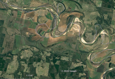
This picture shows the border of Texas and Oklahoma. Since the border was established the Red River has meandered this leads to a strange looking border. The border does not match the River; at some points the border even covers oxbow lakes that were once part of the border. The meandering of the river leads to issues for farmers, hunters, and fishermen as the laws that regulate them can differ between the two states. The motion of the river can lead to people losing land if the river meanders to their property.

DNA discovered in sediment

This article discusses how ancient DNA of extinct human relatives has been found in a cave in Croatia. Tiny DNA fragments were found in sediments in the cave. These sediments date back from 14000 to 550000 years ago. The discovery of DNA in sediments can be seen as a new way to learn about the past. Hopefully this technique leads to many more exciting discoveries in the future.


https://www.sciencedaily.com/releases/2017/04/170427141708.htm

The Belo Monte Dam controversy

This article discusses the controversial Belo Monte Dam located in Brazil on the Xingu River. The Dam is supposed to bring a large amount of hydroelectric energy to the country, as Brazil has a growing economy and is in desperate need for more power. What makes this dam so controversial is that with its construction many indigenous people will be displaced. The article says that 20,000 people have been displaced, however they estimate that it may be as high as 50,000 people. Despite Brazils need for more power to grow economically is it really worth it if it results in tens of thousands of people losing their homes?


https://www.newsdeeply.com/refugees/community/2017/04/28/brazilian-tribe-fear-displacement-by-xingu-rivers-rising-tide

Internship at Alpine Ocean

April 26, 2017

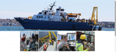
This Summer, I will likely have a crew position on an oceanographic research vessel of Alpine Ocean, a division of Gardline group, a company which specializes in Geophysical surveys, vibracore and geotechnical services, Hydrographic survey services, as well as oceanographic survey services and enviornmental, biological and marine wildlife survey services. Sediment transport studies are involved and subaqueous cores will be drilled, so I’m very excited to have the opportunity to work on a vessel focused on many aspects of geoscience, and specifically sedimentology. I will be away on trips for 2-4 weeks at a time, working 12 hours on, 12 hours off, and will likely have tasks pertaining to the operation and maintenance of the vessel as well as assisting in research and data collection. Our first trip will likely be off the coast of Virginia, but subsequent trips this summer could be anywhere in the world. I will be going to survival training in two weeks in New London which I’m moderately excited for, but I cannot wait to be out on the open ocean helping operate the vessel and collect data

Paleosols at Badlands National Park

April 18, 2017

Last summer, my parents visited a lot of national parks, including Badlands National Park in South Dakota. They showed me all the fossils they saw, which were really cool, but they also showed me photos of the iconic red banding in some of the rock formations there. These bands are part of the Brule Formation, which formed around 30 million years ago, during the Oligocene, as forest transitioned into savanna.

The distinctive red banding in Badlands National Park. Photo credit: Dennis Frates/Alamy.

The red layers are all paleosols, which formed on a “broad, aggrading floodplain“. These developed slowly, and are interspersed with the white layers, which are channel and overbank deposits. Paleosols, as ancient soil deposits, are generally characterized by root traces and soil horizons. Personally, I just thought it was really cool that the paleosols here help to create such beauty in this landscape, and are a very recognizable feature here.

Evidence from central Mexico supporting the Younger Dryas extraterrestrial impact hypothesis

This paper examines sediments of Lake Cuitzeo of central Mexico, and interprets very strange components of a strange unusual layer of materials dated to the beginning of the Younger Dryas. This unique lacustrine carbon rich layer posesses traces of microspherules which have been interpreted as evidence of a cosmic impact. Data was attained from a 27 meter deep core, of which the area of concern is a 10 centimeter thick layer 2.8 meters in depth which is extremely rich. This layer is dated to 12900 years before present, and seems to have been deposited simultaneously with independent environmental changes. These impact indicator sediments, nanodiamonds and microspherules, all peak in abundance directly below a layer of extremely abundant charcoal. The layer of abundant nanodiamonds is aligned with the onset of the Younger Dryas, and no terrestrial processes pose any explanation for their abundance. These findings are consistent with many other cores taken across North America, Europe, and Greenland. Further study is needed to determine if the hypothesized extraterrestrial objects resulted in an airburst or surface impact 12.9ka, but some combination of the two is certainly possible.

Lake Cuitzeo is the 2nd largest lake in Mexico, over 300 square kilometers. And along the Trans Mexico Volcanic Arc, a tectonically active region, the lake lies at a very high elevation above 1800 meters. The core drilled in this lake was 10 centimeters in diameter, as extracted in 1997.

The leading hypothesis asserts that such an impact would be the result of Earth’s encounter with a dense debris field from a fragmenting comet. It has been proposed that a likely airburst coupled with small surface impacts would leave observable debris on more than 10% of Earth’s surface. The Taurid Meteor Stream has been the primary culprit of this source of debris, possessing 19 near Earth asteroids with diameters up to 5km.


Magnetic Impact Spherules- scale represents depth


Israde-Alcántaraa, Isabel, James L. Bischoffb1, Gabriela Domínguez-Vázquezc, Hong-Chun Lid, Paul S. DeCarlie, Ted E. Bunchf, James H. Wittkef, James C. Weaverg, Richard B. Firestoneh, Allen WestI, James P. Kennettj, Chris Mercerk, Sujing Xiel, Eric K. Richmanm, and Charles R. Kinzien. “Evidence from Central Mexico Supporting the Younger Dryas Extraterrestrial Impact Hypothesis.” Proceedings of the National Academy of Sciences. National Acad Sciences, n.d. Web. 17 Apr. 2017. <http://www.pnas.org/content/109/13/E738.full>.

Density Differences in the Flume

April 17, 2017

A few weeks ago, we went down to the lab and played with the flume to simulate a hyperpycnal flow. This was cool on its own to watch, but I was struck by the how some of the water we poured in sat in one of the basins. When the water was originally added, it applied a lot of shear stress to the sediment in the flume, and so created the large scour on the right side. Then, most of the water flowed outward to the rest of the flume, but some stayed in the mini basin we’d created. As seen in the picture above, the darker blue water, which constituted the hyperpycnal flow, stayed very neatly in this basin. I found it surprising that, although the only thing above the denser water was other water, it was still incapable of escaping the basin, and was held there just like sediment would be. Eventually, though, the cooler, more saline water would have begun to mix with the ambient fluid, and we would see the water leave the basin.

Sediment Budget and Coastal Hazards

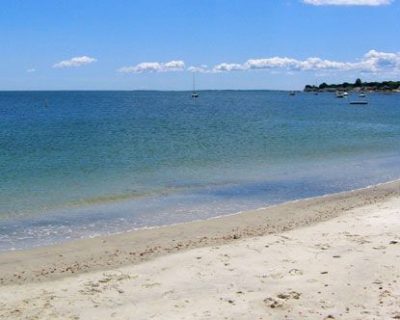
While in the field this past Saturday, we had the opportunity to observe how sediment is dispersed along the Connecticut coast and talk about the origin of the sediment. From glacial lake Hitchcock, several subaqueous fans (deltas) were created. As the glacier retreated, the delta morphosequences were deposited further and further north. These deposits are what make up CT beaches today! While you are on these beaches, notice the medium grained sand that comprises the beaches indicating you are located on the more distal part of an old delta. Pictured below is Rocky Neck, a beach in CT.

http://www.ct.gov/deep/site/default.asp

Old Roman Aqueduct Found

April 16, 2017

A 2,300 year old aqueduct was just uncovered in Rome while working on a new Metro line.  The aqueduct was found 17 to 18 meters below the Earth’s surface.  The use of concrete bulkheads allowed them to be working that far below the ground.  At this depth in the Earth, archaeologists have uncovered a sequence of stratigraphy from the Iron Age that includes this aqueduct and other structures that show evidence of what ancient Romans ate and what animals they had.

http://www.zmescience.com/science/archaeology/rome-aqueduct-10042017/


Flushing Water Mains for Sediment

I saw this article talking about how the town Jackson MI was going to flush the water mains for iron and sediment. The water is still safe to drink, but could be discolored, and people are recommended to not wash their clothes with it. Since I study water, I was interested in the need to flush the pipes, sediment should be filtered out in the treatment system. Any thoughts? How did the sediment get in there?

http://www.mlive.com/news/jackson/index.ssf/2017/04/city_to_flush_iron_sediment_fr.html

Mud and… Elephants, Apparently

April 8, 2017


File:Baby elephant mud bathing chobe.jpg
A baby elephant having a good time in the mud. Credit: Wikimedia.

The other day I came across an article about a herd of elephants stuck in a mud hole in Cambodia. They were all rescued, thankfully. I didn’t save the article, though, and when I went to search for it again, I discovered something: there are a lot of news stories about elephants getting stuck in the mud. There’s the one from a few days ago, which I originally saw, this one about a baby elephant in Zimbabwe from last year, and a lot more, as a quick google search will reveal.

This is common because of their behavior. Elephants will often “bathe” in mud or dirt, and this helps them to cool off. They can’t sweat, so the evaporative cooling of the mud has the same function, allowing the heat from their bodies to be dissipated. It also helps them protect against sunburns.

Well anyway, what exactly is causing the elephants to get stuck? First, mud is a combination of silt, clay, and water. As anyone who’s touched mud can attest to, mud is highly cohesive and adhesive (it sticks to itself and other things), due to the bonds both clays and water make. So, attempting to move through a viscous mud hole is already going to be a taxing ordeal. Furthermore, it’s easy for mud to dry and become even stickier. Often, these elephants are found trapped because the mud has become dry and tacky around them.

Sediment in Venice

Inspired by my upcoming trip to Italy, my discussion this week looks at sediment in a lagoon in Venice. Venice is a city in Northern Italy that is made of many different islands that are connected by canals and bridges. The Venetian Lagoon is the overall term for the area encompassing Venice. Humans have had some significant impacts on the lagoon including subsidence, pollution, fishing, and erosion. The Lagoon has been dredged in many places to deepen the channels which helps contribute to the erosion.

I don’t think that we have any place in the US that is made of many islands such as this, and so we haven’t had to deal with the sediment/flooding issues that Venice does. Do you think that if we did we would have just filled in all the channels and made more space for development?

https://www.deepdyve.com/lp/elsevier/sediment-budget-in-the-lagoon-of-venice-italy-ndsPkPuQLa

Beach Restoration: An Effort to Counter Storm Surge

April 5, 2017

http://www.chron.com/neighborhood/bayarea/news/article/Galveston-puts-last-of-1-million-cubic-yards-of-11031401.php#photo-12200804

In this article from the Houston Chronicle, the restoration of beaches on Galveston Island, a barrier island in Texas, is discussed.  This project, coming after a failed proposal to use tax money to raise the sea walls, attempts to help counter storm surge while also maintaining economic benefit due to tourism by widening the beach.  Along with the contractor leading the project and the Army Corps of Engineers, the city of Galveston is undergoing its 3rd beach restoration project since 1995, with the last coming in 2009 after Hurricane Ike.  The plan is for this to suffice for 5 years, with more maintenance being completed then.  This does concern me though that restoration efforts, necessary as a result of rising sea level and storm surges, will prove too costly and potentially not leave enough time to build up sea walls when it becomes clear to the state of Texas that that would likely be the most viable, long term solution to protecting the coast from the rising sea waters.

A Lesson to Learn from the British

http://www.iwcp.co.uk/news/news/investigation-into-coastal-erosion-around-the-isle-of-wight-98121.aspx

Politicians in the community of the Isle of Wight in Britain have organized a pair of studies to determine the risk of and put in place preventative measures to deal with sea level rise.  This risk assessment, while viewed as a precaution at this point due to a lack of imminent danger, will allow for better planning for the future.  As seen in coastal communities, such as Miami or New York City, waiting for a disaster and responding to it can be disastrous, while a look at the Netherlands and these studies in Britain show that taking preventative measures when dealing with sea level rise, storm surge, and coastal erosion can save a country/city from severe economic impacts.   While the initial investment may seem like it isn’t feasible, it can be beneficial in the long run if it saves the city/state/country from a lot of damage.

Knickpoints and Canoe Racing

April 3, 2017

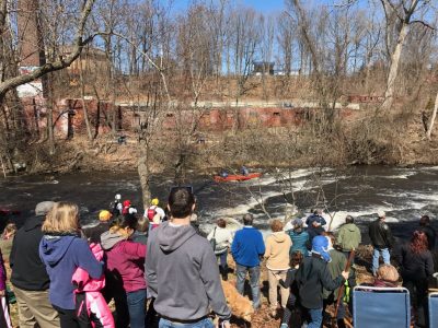
While canoeing down the Hockanum River, my dad and I got to navigate the Beacon Falls rapids. These rapids are formed due to lithologic knickpoints. Most likely these knickpoints are migrating due a combination of glacial rebound and erosion.  Below is a picture of my Dad and I during the Hockanum River Race.

Footage of Turbidity Current

April 2, 2017

This video shows a turbidity current 400 meters deep in the Mendocino canyon off the coast of California.  An underwater ROV captured the event.  In the video you can see the different stages/layers of the turbidity current pass by the ROV (dilute flow, dense basal layer) .

Filtering Croton Water

Yesterday I visited the Old Croton Aqueduct with my club (Soil and Water Conservation Society).  We were able to walk into the 41 mile aqueduct built in the 1800’s, and see how it worked, and learn some of the history behind it. It was New York Cities first clean source of water (after they polluted all of the natural springs). Croton water was clean and clear, until more recently (about 1970’s) when it was decided that a filtration plant needed to be built to prepare for increasing sediment in the water from the rapid development in the watershed. New York’s other source of water-the Catskill/Delaware systems are not treated, and there are no plans to treat them or remove sediment.  This is because New York City has a memorandum of agreement to keep the watersheds in the Catskills/ of the Delaware River clean of pollutants and development. The protected sources keep the water clean, and without need for treatment.

New Recording of a Turbidity Current

April 1, 2017

Researchers were able to record a large turbidity current in Monterey Canyon off of the coast of California in January.  The mass of sediment moved more than 50 km from a depth of 300 m below the sea level to more than 1800 m below the sea level.  The turbidity current moved over 8 m/s at certain times.

There is not very much data or recordings of turbidity currents, so this was an important finding.  The researchers used a new piece of technology called the Benthic Event Detector (BED).  It is a sphere that can measure pressure, orientation, flow velocity, amount of sediment, and how the flow moves down the canyon floor.  The BED is able to collect this data despite the large force and abrasion of the turbidity current.  This new information will help the researchers learn more about what triggers the turbidity currents and how they move across the seafloor.

It is thought that 400,000 cubic meters of sediment is moving down Monterey Canyon each year, which brings nutrients and organic matter to the abyssal plain where it can then support the life found there.  Previous studies have been mostly done using deposits from turbidity currents, but recordings of the currents as they happen will vastly improve the understanding of the turbidity currents.

http://www.bbc.com/news/science-environment-38310108

What is Marine snow?

March 29, 2017

Marine snow – though it sounds like magical ice snowflakes drifting through the ocean is actually made up of many more particles than its land counterpart. When things happen in the ocean such as dying/decomposing animals particles of these events break up, and slowly drift down to the sea floor. These biological components and additional sediment/inorganic particles are marine snow. As they slowly fall through the water, smaller particles can aggregate into larger, fluffy “snowflakes.” The slow, but constant fall of these particles provides an influx of nutrients to the organisms that live at the bottom of the ocean. Whatever isn’t consumed becomes part of the “ooze” that blankets the floor. (NOAA)


Today, of course, we understand the function of marine snow. It helps to provide nutrients to organisms living in the deep ocean. However, this wasn’t always the case. For a long time, scientists were puzzled; how did organisms living on the seafloor get food in the first place? And, once they knew of these particles, how did they actually get there? Essentially, researchers saw that these particles are originally eaten by zooplankton, and packaged in a coating which preserves them on their way down. But the coating itself still isn’t enough to create the “snow” in the amounts researchers were observing. It’s likely that the fecal pellets combine with other aggregates and larger particles, and that these all float down together. This would make sense, since many of the “snowflakes” are fibrous and sticky.


Because marine snow is constantly falling, there is a thick layer of it on the seafloor. Just like sediments, digging a few layers into this is representative of a large expanse of time. This is extremely useful evolutionarily, as it makes it easy to track developments of microorganisms. Further, unlike many microorganisms which can evolve relatively quickly, these organisms operate on longer time scales because nutrients are so sparse.


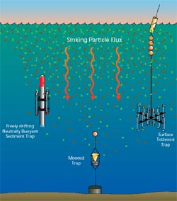
Sediment Traps are used to sample the marine snow (See Figure 1). Marine sediment at the bottom is sampled using a moored trap, and tethered traps are used to catch falling snow. The sediment traps are relatively simple, consisting of a funnel that catches the snow, and a jar to collect the snow. This is attached to a buoy, or anchored so that it can be found again. The data from these traps tells researchers how fast snow is falling through the column, what it is made of, and how fast events at the surface will be felt by the deeper ocean. The downside of the traps is that they catch snow falling vertically, if the trap gets shifted horizontal in storm events, it won’t be able to accurately capture falling snow. (WHOI)

Figure 1: Sediment Traps used to sample marine snow. (WHOI)
Madeline Kollegger and Taylore Grunert

Works Cited

US Department of Commerce, National Oceanic and Atmospheric Administration. (2013, June 01). What is marine snow? Retrieved March 25, 2017, from http://oceanservice.noaa.gov/facts/marinesnow.html


Honjo, Susumu. “Marine Snow and Fecal Pellets”, Oceanus Magazine, vol. 40, no. 2, 1997. Retrieved March 28, 2017 from

https://www.whoi.edu/oceanus/feature/marine-snow-and-fecal-pellets


Marlow, Jeffrey. “The Slow LIfe Movement: A Microbial Perspective of the Subsurface Biosphere”. Discover, March 23, 2017. Web. Retrieved March 28, 2017 from http://blogs.discovermagazine.com/the-extremo-files/2017/03/23/501/#.WNUWmhLytE4


The Fastest Eroding Coast in Europe

March 27, 2017

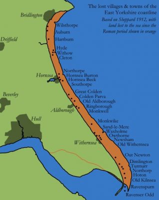
Along the Yorkshire coast from Flamborough Head to Spurn Head, the coast is eroding faster than anywhere else in Europe.  The coastline loses an average of 5 feet of land every year and about 29 villages have been lost to the sea since the Roman Empire.  This area is bounded by the North Sea with the Humber estuary in the south.  The reason for this extreme erosion is mostly because the area is very flat and swampy and is underlain by a soft clay that easily erodes.

The sediment is taken from the north and transported down south to Spurn Head.  Spurn Head is a spit, which is a narrow stretch of land extending into the sea.  Spurn Head gains about 3% of the sediment that the northern coast loses.  Although measures have been taken to slow the loss of sediment, like seawalls and jetties, the land is still being lost to the sea at fast rates.  It doesn’t help that the land is subsiding and sinking at 3mm per year and the sea level is also rising.

This figure shows the amount of land that has been lost in orange and the present coastline in green.  It also shows the towns that have been lost over the last several hundreds of years.

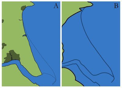
These figures show how the coastline will look in 1000 years.  Map A assumes there will be no more sea level rise, so Map B is more likely.

http://bigthink.com/strange-maps/a-map-of-europes-fastest-eroding-coast

Assateague Island

March 26, 2017

Assateague Island and Ocean City have been losing land from sea level rise, extreme weather events, and subsidence. Since 1960 the sea level has risen 5 inches and storms have been becoming more intense in recent years. On Google timelapse you can see how the coastline has receded on Assateague Island, while long shore drift has extended the barrier island. Ocean City is adding more sand to its beaches because of expensive seaside properties, but Assateague Island is moving some of its campsites and facilities farther back because of the land loss.

http://www.delmarvanow.com/story/opinion/editorials/2017/03/24/assateague-ocean-city-sea-level/99575644/

https://earthengine.google.com/timelapse/    and search Assateague Island

Barrier Island Evolution

March 25, 2017

https://earthengine.google.com/timelapse/

Google Earth Engine Time Lapse: Gargathy Bay, Wallops Island, VA, United States

Zoom to this location and look at the changes of the northern barrier island as it progrades to the southwest. The barrier island has grown by a substantial amount. This is due to wave defraction eroding sediment from the barrier island and displacing it to the southwest.

Gleying

March 24, 2017

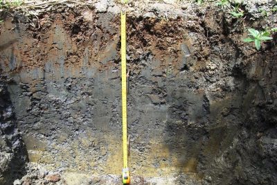
(http://2.bp.blogspot.com/_6CGtXcavSuo/S-wH-dT28nI/AAAAAAAAAS0/WiTeWCZFDOQ/s1600/gleyed+soil.JPG)

The image above is an example of gleying in soil. What is gleying? It is when low oxygen soil conditions (such as a high water table) cause iron and manganese to reduce, and make the soil gray. There are some cases where plants grow in soils that have low oxygen, and the roots that go into the gleyed soil provide just enough oxygen so that iron and manganese don’t reduce, and the soil remains an orangey color- just around the roots.

I wonder if this phenomenon can be seen in the sediment record, or if it is specifically only visible in a more short term?

Mother Nature Reclaims the Land

March 22, 2017

http://www.mercurynews.com/2017/03/10/battered-by-winter-storms-big-sur-is-cut-off-from-california/

California received some much needed precipitation over this past winter, lifting it out of a severe drought.  This was not without its problems however, as the sharp increase in precipitations have led to landslides in parts of the state.  One notable example of this was the small town of Big Sur, which has essentially been cut in half and cut off from the rest of the state.  The increase in the water in the system allowed for the transport of more sediment.  Unfortunately, this led to landslides not only closing off the highway south of the town, but also damaging a key bridge beyond repair, closing off the town from the rest of the state.  The precipitation was necessary, but it also had destructive consequences.  This may have shown the need to have a contingency plan in place in case key routes to towns in landslide prone areas get blocked off by the landslides.

Colorado River Delta Restoration Efforts

http://news.nationalgeographic.com/news/special-features/2014/12/141216-colorado-river-delta-restoration-water-drought-environment/

This article described restoration efforts of the Colorado River Delta, a joint US-Mexico attempt to restore biodiversity to the region.  The delta had dried up as hydroelectric dams had been installed along the river, leading to desertification of the region.  This is a region incredibly rich in nutrients due to the amount of sediment carried by the Colorado River, though the river drying up led to this area on the border between Mexico and Arizona losing much of its vegetation and many of the animals that made it their home.  Even a single large pulse of water was enough to return biodiversity to the region, so if this restoration effort can maintain a flow of water to the region, it could not only return vegetation to the region, but it could also help prevent soil erosion as the roots from trees can help hold sediment in place.  This is a fine line to walk however, as this pulls water away from other regions that depend on reservoirs formed along the Colorado River.

Major Rivers without Deltas


Narmada River in India

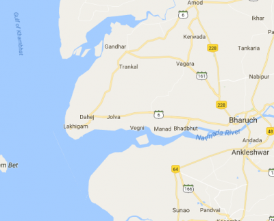
The Narmada River flows east to west, and is 815.2 miles long. It  originates in a small reservoir called Narmada Kund at a fairly high elevation, and empties into the Gulf of Khambhat. The high source elevation gives the water a lot of force, as the flow of the water is gravity driven. Much of the river’s path includes waterfalls, with a bed made of rock, such as basalt, and magnesium limestone. Despite having a mostly rock bed, the river does get sediment input from its many tributaries. However, the Gulf has a lot of water action, removing all the sediment that gets deposited by the river- meaning that a delta cannot form. In addition, the gradual widening of the channel (see Map 1) prevents the sediment from adequately building up on the banks, as the channel is the rift valley between two different mountain ranges.

Screen Shot 2017-03-05 at 3.12.02 PM

Map 1. A map of the Narmada River, where it meets the ocean.


The St. Lawrence River in Canada


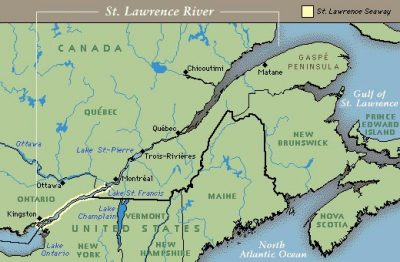
The St. Lawrence River is one of the largest rivers in North America, stretching 744 miles from Lake Ontario to the Atlantic Ocean. It provides drainage for the entire Great Lakes system, and is 250 feet deep at its deepest point. It has historical importance as a trade route and water source, and also serves as a natural border between Canada and New York.


The river empties into the eponymous Gulf of St. Lawrence. Though this is an estuary, and thus protected from the ocean, the tidal forces of the Atlantic Ocean still play a big role here. Furthermore, the St. Lawrence River transports an extremely small amount of sediment for its size. This is because the Great Lakes do not supply much sediment to the river and because of the geology of the river basin. Both of these factors, oceanic forces and low sediment load, combine so that a delta doesn’t form in the Gulf of St. Lawrence; hardly any sediment is deposited there, and what is supplied is almost immediately washed away.

StLawrenceRiver_PhotoMap

Map 2. The Gulf of St. Lawrence.


Taylore Grunert and Madeline Kollegger

Works Cited:

Dunn, Rob. “The Generous Gulf”, National Geographic, May 2014. Web. Retrieved March 6, 2017 from http://ngm.nationalgeographic.com/2014/05/gulf-of-st-lawrence/dunn-text

“The Estuary and the Gulf of St. Lawrence”, Fisheries and Oceans Canada, Feb 2, 2017. Web. Retrieved March 6, 2017 from http://www.qc.dfo-mpo.gc.ca/golfe-gulf/index-eng.html

“Facts about the Upper St. Lawrence River”, Save the River, 2014. Web. Retrieved March 6, 2017, from http://www.savetheriver.org/index.cfm?page=app.riverfacts

Holeman, John N. “The Sediment Yield of Major Rivers of the World”, Water Resources Research, vol. 4, no. 4, 1968, pp. 737-747.

Koutitonsky, V. G. and G. L. Bugden. “The Physical Oceanography of the Gulf of St. Lawrence: A Review with Emphasis on the Synoptic Variability of the Motion”, Canadian Special Publication of Fish and Aquatic Sciences, vol. 113, 1991, pp. 57-90.

Loring, D.H. and D. J. G. Nota. Morphology and Sediments of the Gulf of St. Lawrence, Environment Canada, 1973, Ottawa.

Narmada River. (n.d.). Retrieved March 05, 2017, from http://www.mapsofindia.com/maps/rivers/narmada.html

Mississippi Delta Restoration

March 7, 2017

Engineered levees are preventing deposition of sediment on the Mississippi Delta marshes and floodplain. This is leading to subsidence and land loss as sediment is no longer escaping the Mississippi River. Here is a link that looks at projects which will aid in preventing land loss: http://mississippiriverdelta.org/restoration-solutions/

Yukon River Delta

March 4, 2017

IDL TIFF file

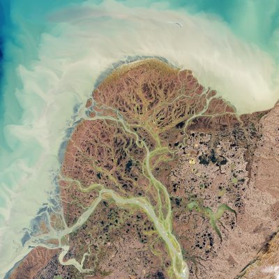
This is the Yukon River Delta. It is a river dominated delta where the Yukon and the Kuskokwim rivers meet and empty into the Bering Sea in Alaska. It is one of the largest deltas in the world (129,500 sq km) and 25,000 people live on the delta. A lot of the delta is a wildlife refuge of wetlands and tundra with many ponds and meandering rivers. Because of this, there are many species of water birds living on the delta. The delta has many smaller meandering channels that have split off from the Yukon and the Kuskokwim.

Yellow River Delta

0013729e42ea0c23a34360

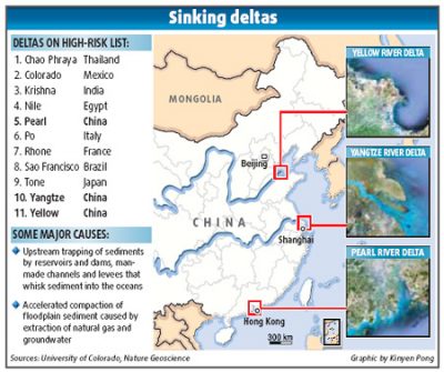
I learned ( In my Natural Resources of China class) that much of the lowlands of China are a delta formed by the Yellow and Yangtze Rivers in China. This is where they do much of their agriculture, because most everywhere else in  the country is too mountainous. The Yellow River Delta is a river dominated delta, because of the protection from wave/tidal action provided by Japan and other islands. It is at risk of sea level rise, because much of the sediment supply to the delta is being cut off by the large number of hydroelectric dams on the river, and its tributaries. These often need to be dredged out because there is a lot of sediment in the water-because of the energy and force of the flow. The water comes off of the Tibetan Plateau, and is gravity driven to the ocean. Since the plateau is so high, there is a lot of force in the flow.

The Potential Effects of Climate Change on Sediment Transport

March 1, 2017

http://news.nationalpost.com/news/world/drained-bone-dry-battling-15-years-of-drought-colorado-river-could-decline-by-35-by-end-of-century

In the article above, the work of several researchers and the predictions from multiple climate models was discussed.  The research done focused on the effects of climate change on the flow of the Colorado River, particularly the decrease in flow.  Due to drought and rising temperatures, the flow of the Colorado River has been down almost 20% from the century’s average.  This is concerning, as estimates have it declining by 25 to 35% by 2100, with the upper estimates at over 50%.  A decrease in flow will significantly affect sediment transport within the region, as the stress needed to transport grains is dependent on the thickness of the fluid.  If flows drop significantly, it will lower the amount of basal shear stress on the river bed, and as a result, less sediment will be transported.  The loss of flow and entrained sediment could then affect the Colorado River Delta, affecting the wetlands at the mouth of the river.

Aral Sea

February 26, 2017

On google earth timelapse you can see how the Aral Sea shrivels up to almost nothing. The Aral Sea is fed by the Amu Darya River in the south and the Syr Darya in the east/north. The Aral Sea began drying up after the Soviets began diverting the rivers for irrigation. By 2007 it was just 10% of its original size. The dried up basin is now a desert called the Aralkum desert. This just shows how important rivers are, and changing their paths can lead to devastation of areas that relied on the rivers.

Search Aral Sea on google earth timelapse

https://earthengine.google.com/timelapse/

Fluvial Responses to Landslides

February 25, 2017

Google Earth timelapse shows amazing imagery of what happened before and after several landslides in Oso, WA. The river experiences a large build up of sediment upstream while downstream the river does not get as sediment choked. The landslide dams the river causing an increase in slope upstream, increasing basal shear stress, causing more sediment to flushed downstream towards the landslide dam. Eventually, the dam is breached.

Check it out! Search bar: Oso, WA and link to Earth Engine: https://earthengine.google.com/timelapse/

Rakaia River Timelapse

https://earthengine.google.com/timelapse/#v=-43.53499,171.73082,10.818,latLng&t=0.00

After being inspired be a class discussion on rivers, and Google Earth Engine, I decided to look at rivers in New Zealand, and make a timelapse of its changes over time. I looked at the Rakaia River, which seems to be both meandering, and braided in parts. I think this helps exemplify that identify a river type depends on your perspective, and the scale that you choose to see the river in.

Using Layers of Sedimentary Rocks to Describe Planetary Rotation

February 23, 2017

Most people assume that the rotation of the planets in our solar system around our sun is a fixed, predictable thing. These  orbits can be mathematically computed and relied upon, and not much changes in a rotation besides the known Milankovitch cycles. The real world, it turns out, is much more complex. The planets actually rotate via the “Chaotic Solar System”, a theory which had no hard proof until very recently. This theory states that minuscule interactions between flying planets can, over time, throw off orbits completely, and make planetary loops much more random and disorganized. Under this theory, there is potential for planetary impacts to occur millions of years down the line, between Earth and Mars and even Earth and Venus. How do we know this model is correct? A recent study done by examining sedimentary rocks in Colorado helps describe the oddities of our planets rotation around the sun, and its complexities and irregularities could only exist in this Chaotic Solar System theory. Read this article for more information:

From rocks in Colorado, evidence of a ‘chaotic solar system’

The Breathtaking Scenery of Zion National Park

February 22, 2017

Zion National Park is the home of many spectacular landscapes, perhaps most notably, Angels Landing.  This, like many of the other features within the park, were formed by rivers carving through the sandstone, forming massive slot canyons and carving the landscape around the plateaus.  While treacherous due to the height of some of these cliffs, which can be a prime destination for rock climbers, the view is breathtaking.  Zion is a great example of just how powerful water can be, especially when cutting through sandstone, and a place I would love to visit someday.

https://www.doi.gov/blog/8-things-you-didnt-know-about-zion-national-park

Dust Storms

February 21, 2017

Dust storms are to deserts what floods are to rivers. They are quick, massive, and dangerous.  Like floods, they can also cause destruction to infrastructure, including homes, and people have been killed by them (Giuggio). However, the main danger presented by dust storms is longer term than being buried under piles of sand.

Dust storms have the ability to spread pathogens all over the world (Vidal). They have the power to pick up heavy metals, viruses, and harmful chemicals (Main). Because the dust particles are small, they can be just as harmful as smog, for example, in delivering toxins deep into the body (Vidal). This concern will only grow as humans have a greater impact on the environment. Many activities, especially those concerned with agriculture, are drivers of both frequency and magnitude of dust storms (“Global Assessment of Sand and Dust Storms”).

Further, long term exposure to airborne dust particles has been shown to have negative health effects. Dust can exacerbate respiratory problems, such as asthma (Park et. al.). They have also been shown to drive up mortality rates generally, though the exact mechanisms for this are less clear (Perez et.al.).

While Dust storms pose an intense threat to human health, they are also an indicator to the overall health of the planet. The increased amount of particles in the air not only add to the quantity of dust, but also helps to magnify the effects of global warming, and climate change. This in turn would cause the Earth to dry more, and therefore more dust storms to occur (Todorova). The increase in Dust storms can pose problems for areas such as Syria and Iraq, destroying crops, and causing people to flee their homes, in this case as climate refugees.     

 Situations such as this, (destroying crop fields and plant life) is reminiscent of the Dust Bowl Phenomena in the United States. Known as the “Worst Manmade Ecological Disaster,” the phenomena occurred because of the rapid conversion of grassland to agricultural land, which didn’t hold the soil in place as wind swept by. There were thousands displaced by this event-which lasted about 10 years on an overall scale, until drought was replaced by rain, and the dust settled, and plants began to slowly grow back (West). This same situation could be in the imminent future, but will not heal with rain, because global warming and climate change will make area’s that are dry, drier, and not give them a reprieve with rain.

Taylore Grunert and Madeline Kollegger

Works Cited:


Giuggio, Vicki M. “How Dust Storms Work”. How Stuff Works, n.d. Web. Retrieved 20 Feb. 2017 from: http://science.howstuffworks.com/nature/climate-weather/storms/dust-storm5.htm

Main, Douglas. “7 Crazy Facts about Dust Storms” Live Science, 24 Apr 2013. Web. Retrieved 20 Feb 2017 from: http://www.livescience.com/31923-7-crazy-dust-storm-facts.html

Park et al. “Effects of ambient particulate matter on peak expiratory flow rates and respiratory symptoms of asthmatics during Asian dust periods in Korea”. Respirology, vol. 10, no. 4, Sep 2005, pp. 470-476.

Perez et al. “Coarse particles from Saharan dust and daily mortality”. Epidemiology, vol. 19, no. 6, Nov 2008, pp. 800-807.

Todorova, V. (2016, May 23). Climate change could lead to more dust storms in UAE, study shows. Retrieved February 21, 2017, from http://www.thenational.ae/uae/environment/climate-change-could-lead-to-more-dust-storms-in-uae-study-shows

UNEP, WMO, UNCCD. “Global Assessment of Sand and Dust Storms”. United Nations Environment Programme, Nairobi. Edited by: Gemma Shepherd, UNEP.

Vidal, John. “Dust storms spread deadly diseases worldwide”. the guardian, 26 Sep. 2009. Retrieved 20 Feb. 2017 from: https://www.theguardian.com/world/2009/sep/27/dust-storms-diseases-sydney

West, L. (2016, July 05). Dust Bowl: The Worst Environmental Disaster in the US. Retrieved February 21, 2017, from http://environment.about.com/od/environmentalevents/f/dustbowl.htm
 

Rainstorms in California

California is having a rough couple of weeks.  Over the weekend a huge rainstorm hit Southern California.  They received between 2-6 inches of rain, with almost 10 inches of rain in some areas.  Because the ground was already oversaturated from what has been a very wet winter, there were major flash floods and a few sinkholes.  There is also a higher probability for mudslides after all of the rain, which could cause more damage.  Southern California has received 400% more than the average rainfall this winter.  And the rain is continuing over Northern California where the Oroville Dam is located.  The spillway is still eroding, but the dam has not broken yet.  All of this rain is causing damaging amounts of erosion.

https://www.washingtonpost.com/news/capital-weather-gang/wp/2017/02/18/historic-storm-pounds-southern-california-with-high-winds-and-record-rain/?utm_term=.626c885e21e1

Dunes on Mars

Mars Dunes

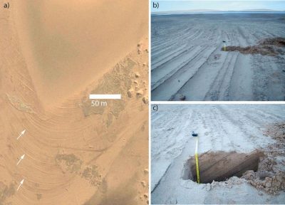
Figure 1. a) Features found on Mars, b) and c) features found in Namibia.


European scientists M.C. Bourke and H.A. Viles from the University of Dublin and the University of Oxford, have been studying coastal dunes in Namibia because they are similar to features that have been found on Mars. Based on their studies, they have hypothesized that the Martian valley features were formed from salts left behind after the groundwater evaporated. In Namibia, the scientists found features formed from migrating sand dunes, which were then covered by salts left from fluctuating amounts of evaporated groundwater. The valley on Mars also shows evidence of fluctuating amounts of salty groundwater. The scientists think that the water on Mars was present not very long ago, so it could be a good place to search for possible life on the planet.

The photograph of the features on Mars look a lot like the cross section of the dunes on the Wilbur Cross columns. The photograph shows the same curved laminations, except on a much bigger scale. The dunes in Namibia also look similar to what we saw in lecture and in lab. The cross section shown in c) shows dipping strata and the ridges on the surface shown in b) are long and linear features. This is characteristic of waves or back and forth motion, which we also saw on sample 20 in lab.

This is a very interesting application of sedimentology. Even the planetary sciences call for the study of sediment and sedimentary structures. Knowing what causes certain sedimentary structures to form on a planet surface can help scientists learn about what processes are occurring on different planets. This can then lead to discovering the presence or historical presence of water, and possibly extraterrestrial life.

https://www.inverse.com/article/27904-martian-valley-water-extraterrestrial-life