Narmada River in India
The Narmada River flows east to west, and is 815.2 miles long. It originates in a small reservoir called Narmada Kund at a fairly high elevation, and empties into the Gulf of Khambhat. The high source elevation gives the water a lot of force, as the flow of the water is gravity driven. Much of the river’s path includes waterfalls, with a bed made of rock, such as basalt, and magnesium limestone. Despite having a mostly rock bed, the river does get sediment input from its many tributaries. However, the Gulf has a lot of water action, removing all the sediment that gets deposited by the river- meaning that a delta cannot form. In addition, the gradual widening of the channel (see Map 1) prevents the sediment from adequately building up on the banks, as the channel is the rift valley between two different mountain ranges.
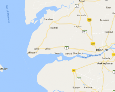
Map 1. A map of the Narmada River, where it meets the ocean.
The St. Lawrence River in Canada
The St. Lawrence River is one of the largest rivers in North America, stretching 744 miles from Lake Ontario to the Atlantic Ocean. It provides drainage for the entire Great Lakes system, and is 250 feet deep at its deepest point. It has historical importance as a trade route and water source, and also serves as a natural border between Canada and New York.
The river empties into the eponymous Gulf of St. Lawrence. Though this is an estuary, and thus protected from the ocean, the tidal forces of the Atlantic Ocean still play a big role here. Furthermore, the St. Lawrence River transports an extremely small amount of sediment for its size. This is because the Great Lakes do not supply much sediment to the river and because of the geology of the river basin. Both of these factors, oceanic forces and low sediment load, combine so that a delta doesn’t form in the Gulf of St. Lawrence; hardly any sediment is deposited there, and what is supplied is almost immediately washed away.
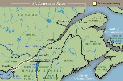
Map 2. The Gulf of St. Lawrence.
Taylore Grunert and Madeline Kollegger
Works Cited:
Dunn, Rob. “The Generous Gulf”, National Geographic, May 2014. Web. Retrieved March 6, 2017 from http://ngm.nationalgeographic.com/2014/05/gulf-of-st-lawrence/dunn-text
“The Estuary and the Gulf of St. Lawrence”, Fisheries and Oceans Canada, Feb 2, 2017. Web. Retrieved March 6, 2017 from http://www.qc.dfo-mpo.gc.ca/golfe-gulf/index-eng.html
“Facts about the Upper St. Lawrence River”, Save the River, 2014. Web. Retrieved March 6, 2017, from http://www.savetheriver.org/index.cfm?page=app.riverfacts
Holeman, John N. “The Sediment Yield of Major Rivers of the World”, Water Resources Research, vol. 4, no. 4, 1968, pp. 737-747.
Koutitonsky, V. G. and G. L. Bugden. “The Physical Oceanography of the Gulf of St. Lawrence: A Review with Emphasis on the Synoptic Variability of the Motion”, Canadian Special Publication of Fish and Aquatic Sciences, vol. 113, 1991, pp. 57-90.
Loring, D.H. and D. J. G. Nota. Morphology and Sediments of the Gulf of St. Lawrence, Environment Canada, 1973, Ottawa.
Narmada River. (n.d.). Retrieved March 05, 2017, from http://www.mapsofindia.com/maps/rivers/narmada.html